
Hurricane Erin rapidly intensified into a rare Category 5 storm in the Atlantic, becoming one of the fastest-growing hurricanes in history. Here’s the path, forecast, impacts, and safety updates.
Why Hurricane Erin Is Making Headlines
Hurricane Erin has captured global attention as one of the most rapidly intensifying storms in Atlantic history. Within just over 24 hours, Hurricane Erin strengthened from a Category 1 hurricane to a Category 5 monster storm, showcasing the dangerous trend of rapid intensification linked to climate change.
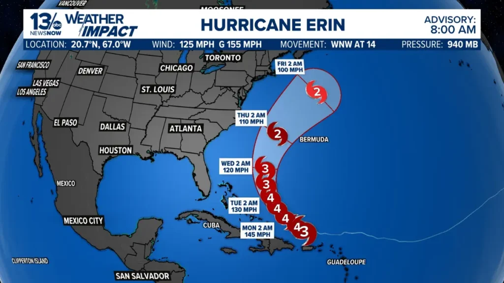
As of August 17, 2025, he has reached Category 4 status again, with maximum sustained winds of 130 mph. While the storm is not projected to make landfall in the United States, its powerful winds, heavy rainfall, and rip currents will have widespread impacts along the East Coast and the Caribbean.
Key Facts About Hurricane Erin
| Detail | Information |
|---|---|
| Storm Name | Hurricane Erin |
| Category | 4 (previously 5) |
| Wind Speeds | 130 mph sustained |
| Location | ~1,000 miles SE of Cape Hatteras, NC |
| First Reached Cat 5 | August 16, 2025 |
| Storm Size | Expanding, tropical storm-force winds extend 230 miles |
| Areas at Risk | Puerto Rico, Turks & Caicos, Bahamas, US East Coast (rip currents, flooding) |
The Rapid Intensification of Hurricane Erin
Meteorologists define rapid intensification as a storm’s wind speed increasing by at least 35 mph within 24 hours. Hurricane Erin not only met but exceeded that benchmark dramatically.
- Friday (Aug 15, 11 a.m.): 75 mph winds (Category 1)
- Saturday (Aug 16, 12 p.m.): Near 160 mph winds (Category 5)
This placed him among the fastest-intensifying storms in Atlantic records, joining an alarming trend of stronger, faster-developing hurricanes fueled by warming oceans.
Why Hurricane Erin Matters: Climate Change Connection
Scientists warn that storms like Hurrican Erin reflect how global warming intensifies hurricanes:
- Hotter sea surface temperatures provide more fuel.
- Warmer atmosphere holds more moisture, leading to heavier rainfall.
- More frequent rapid intensification events are now recorded in August, earlier than typical peak months.
Since 2016, the Atlantic has already seen 11 Category 5 hurricanes, with Erin becoming the latest.
Projected Path of Hurricane Erin
The National Hurricane Center (NHC) forecasts that Hurricane Erin will track north-northeast, avoiding direct landfall but still posing major threats:
- Puerto Rico & Caribbean: Heavy rainfall, flash flooding, mudslides.
- Turks & Caicos & Bahamas: Up to 6 inches of rain, storm surge, power outages.
- US East Coast: Dangerous rip currents, strong surf, minor coastal flooding in North Carolina’s Outer Banks.
⚠️ Emergency Declaration: Dare County, NC, has already issued a state of emergency and mandatory evacuation for Hatteras Island due to expected flooding and ocean overwash.
Hurricane Erin’s Impact on Puerto Rico
- Over 100,000 people lost power on August 17.
- Outer rainbands continue dumping 2–4 inches of additional rainfall.
- Flash flooding and mudslides remain a serious concern in mountainous regions.
Atlantic Hurricane Season 2025: How Erin Fits In
The 2025 season has already seen multiple storms—Andrea, Barry, Chantal, and Dexter—but he is the first major hurricane.
Interesting notes:
- Historically, the first hurricane forms by August 11.
- In 2024, by this time, three hurricanes (Beryl, Debby, and Ernesto) had already formed.
- Erin’s formation was slightly delayed but quickly became historically strong.
Meteorologists expect above-average activity this year, meaning more storms could follow Erin’s path.
Safety Warnings for Coastal Residents
Even though Hurricane Erin is not making landfall in the mainland US, safety officials are warning:
- Avoid swimming in Atlantic waters—rip currents kill 12% of hurricane-related victims.
- Stay away from flood-prone areas along coastal North Carolina.
- Do not underestimate storm size—it is projected to double or triple in size, increasing its reach.
FAQs About Hurricane Erin
1. How strong is Hurricane Erin now?
As of the latest update, Hurricane Erin is a Category 4 storm with sustained winds of 130 mph.
2. Will Erin hit the US mainland?
No direct landfall is expected, but dangerous surf, rip currents, and flooding are likely along the East Coast.
3. Why did Erin intensify so quickly?
Erin rapidly strengthened due to very warm ocean waters and favorable atmospheric conditions — trends linked to climate change.
4. Is Puerto Rico safe from Hurricane Erin?
Puerto Rico avoided a direct hit but still faces heavy rainfall, flooding, and power outages.
5. How rare is a Category 5 hurricane in August?
Extremely rare — Hurricane Erin is one of only 43 Category 5 hurricanes in Atlantic history, and unusual for mid-August.
Conclusion: What Hurricane Erin Teaches Us
He has entered the history books as one of the fastest-intensifying hurricanes in the Atlantic basin. Even without a US landfall, it is already affecting the Caribbean and coastal communities with flooding, rip currents, and dangerous surf.
As climate change accelerates, storms like it will likely become more common, highlighting the urgent need for preparedness and environmental action.